 English
 Română
 Nederlands
2D hydrodynamic model
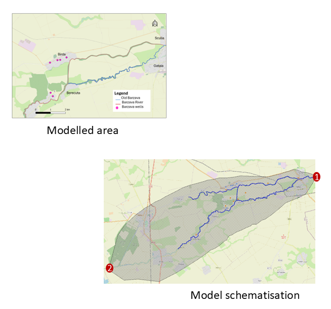
For the region surrounding Birda municipality, a 2D hydrodynamic model has been developed with the HEC-RAS modelling system to simulate flood scenarios of the Barzava river. The model covers a total area of about 128 km², and the modelled section of the river is about 29 km long. Data sets from different sources were used for the development of this hydrodynamic model, such as digital elevation models, river network bathymetry, location and type of different hydraulic structures (such as culverts and bridges), as well as observed hydrological information for model calibration and validation. The model plays a role in gaining an understanding of how the water system behaves during flood conditions. One past flood from the summer of 2016 is used here to provide example results (see the map interface below). This model has been calibrated so that it gives similar results to those presented in the web portal of Romanian Waters with results of their second cycle of flood risk assessment.
This model is then used to simulate flooding conditions under conditions of climate change, as well as with some adaptation strategies, consisting of Nature-Based Solutions (NBSs) combined with existing and future flood defense structures. Selected Key Performance Indicators (KPIs) are used to assess these different flooding conditions. These results can be explored via the tabs presented on the left.
Model inputs
Legend
Model Results - Flood Animation (2016 Event)
The animated output below shows the progression of the 2016 flood event over time, displaying how flood extent and depth evolved throughout the event.
